The Bureau of Meteorology has a history of the effects of cyclones on Port Hedland and it makes fascinating reading if aiming to judge possible fallout from Cyclone Rusty on the iron ore port (h/t Failed Baby Boomer). Storm surge, it seems, has razed the town in the past. Find it below.
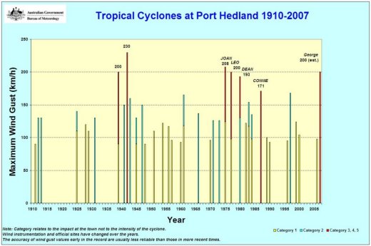
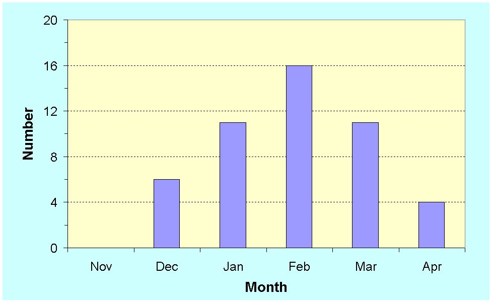
The Pilbara coast experiences more cyclones than any other part of Australia. Since 1910 there have been 49 cyclones that have caused gale-force winds at Port Hedland. On average this equates to about one every two years. About half of these cyclones have an impact equivalent to a category 1 cyclone. Seven of these, Jan. 1939, March 1942, Joan Dec. 1975, Leo March 1977, Dean Feb. 1980, Connie Jan. 1987 andGeorge March 2007 caused very destructive wind gusts in excess of 170 km/h. Along the Pilbara coast the cyclone season runs from mid December to April peaking in February as shown in figure 2 below. The strongest wind gust recorded at Port Hedland during a cyclone is 208 km/h during Joan (1975).
Tracks
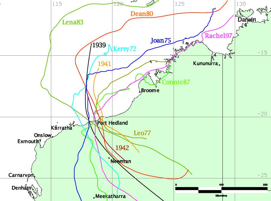
Cyclones that impact Port Hedland typically form over warm ocean waters to the north of the state. Although the typical initial steering of these systems is to the southwest, those that affect Port Hedland take a more southerly or southeasterly track as they move further south as shown in the tracks of notable cyclones affecting the town in figure 1. Some cyclones form from lows that move offshore from the West Kimberley, although they do not typically have time to develop into a severe tropical cyclone.
See also the Interactive Tropical Cyclone Plotting web page to access tracks of historical tropical cyclones.
Flooding
By not being on a major river, Port Hedland is not at risk of major flooding caused by rainfall alone. Nevertheless localised flooding is certainly possible in susceptible areas along creeks and low-lying areas. Major flooding in Port Hedland is typically associated with storm surge, as discussed in the next section. Heavy rainfall inland can cause flooding along the neighbouring major river systems of the De Grey, Turner and Yule that can impact pastoral stations, mining activities and cause transport delays and damage to road and rail infrastructure. TC Joan (1975) caused rainfall to 600 mm resulting in major flooding particularly on the Fortescue and Yule Rivers (see rainfall isohyets), but did not cause flooding in Port Hedland.
The flood potential of a system is not directly related to cyclone intensity but is associated with its track, speed and areal extent. Indeed rainfall totals in excess of 100 mm are common with tropical lows that move over land. In February 2003 a tropical low moved over Port Hedland causing rainfall in excess of 300 mm in some parts and flooding the Yule River, washing away almost 100 m of the road on the western approach to the main bridge on the North West Coastal Highway.
Storm Surge
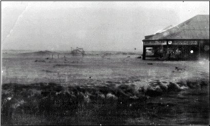
Storm surge is a major threat to Port Hedland. The devastating example of the cyclone of 1939 is a graphic illustration of the potential impact (see description below). The actual water level, called the storm tide is a combination of the storm surge and tidal variation. The worst case scenario is to have a severe cyclone pass near the town near the time of high tide. Given the significant tidal variations, this is a rare occurrence.
However, even a weak to moderate cyclone close to high tide can cause water inundation. In March 1917 a system identified as below gale-force occurred close to a neap tide of 7.6 m and caused sea water 0.7 m deep in parts of the town, with water running through Richardson Street. Apart from the 1939 event, Port Hedland has been fortunate in being spared a significant surge impact. The other severe cyclone impacts – Joan (1975), March 1942 and Connie (1987) occurred close to low tide while Leo (1977) and Dean(1980) passed to the east of the town. The storm surge during cyclone Kerry in January 1973 caused some inundation to parts of the town. TC George (2007) passed east of the town and hence there was no storm surge in the town.

Figure 3. Storm surge at Port Hedland in January 1939.Photo courtesy of Port Hedland Historical Society.
Some Notable Cyclones Impacting Port Hedland
| Tropical Cyclone | Central Pressure (hPa) | Wind Gust (km/h) | Impact Description |
|---|---|---|---|
| 21-22 March 1912 | – | 102 est. | The Bullara and the Koombana, a three-year-old coastal steamer of 3700 tonnes with about 140 people on board left Port Hedland on the morning of the 20th. The Bullara later returned to Port Hedland minus her smokestack after having the eye of the storm pass over her. The Koombana vanished and there were no survivors.This cyclone crossed the coast just west of Balla Balla, the port for the copper mines of the Whim Creek district, early on the 22nd. Damage extended more than 200 kilometres along the coast. A large, iron sailing ship, the Crown of England, was wrecked on Depuch Island; a similar vessel, the Concordia, was driven ashore nearby. Several lighter vessels and pearling luggers were sunk or wrecked. In total the cyclone claimed well over 150 lives. |
| 11 Jan 1939 | – | 200 est. | Thirty per cent of the town’s population were left homeless as a massive storm surge swept through town. The surge coincided with the afternoon high tide to cause an actual tide estimated at 9.8 m (5.7 m AHD). Water was driven to the steps of the Resident Magistrates house located 10.8 m above sea level and 65 m from the normal high water mark. Sea water was 1.5 m deep in the Pier Hotel while floodwaters trapped people on the upper storey of the Esplanade Hotelthat had lost its roof. Three houses and the railway Goods Shed were washed out to sea and a channel was cut by seawater from Airey Point to the back of the Post Office. Nineteen kilometres of road and railway, including the causeway, were washed away. Several properties including a store, garage and the picture theatre were demolished by the wind, and a number of houses unroofed. |
| 24 March 1942 | 938 | 230 est. | All houses suffered some degree of damage, and the Pier and the Esplanade Hotels were again badly damaged. A pile driver was blown off the jetty and nine pearling luggers blown out to sea. One was wrecked with the loss of two lives. Fortunately the tide was low at the time so there was little foreshore damage. |
| Joan, 8 Dec. 1975 | 966* | 208 | Joan was one of the most significant cyclones in WA’s history, crossing the coast 50 km west of Port Hedland. Eighty five per cent of the town’s houses were damaged to some degree especially along the ocean front. The hospital was destroyed and total cost of repairs to buildings in Port Hedland was estimated at $20 million.Heavy rain inland, (Marandoo 591 mm) caused major flooding which included the Yule River. |
| Dean, 1 Feb. 1980 | 963 | 193 | Dean crossed the coast about 50 km east of Port Hedland. A prawn fishing boat was sunk in Port Hedland harbour. Damage in Port Hedland was described as extensive. |
| Connie, 19 January 1987 | – | 171 | Connie crossed the coast just 20 km west of Port Hedland. While several houses were unroofed damage was only moderate. There was no storm surge impact as Connie crossed at low tide. |
| George, 8 March 2007 | – | 200** | George crossed the coast 50 km east northeast of Port Hedland. Although George as rated as a category 5 system at landfall, Port Hedland did not experience the strongest winds of George and maximum gusts in the town were estimated at being of category 3 strength. Three people died at Indee station and at a Rail village camp inland from Port Hedland. Port Hedland sustained only moderate damage, mostly to older structures. |
* A barometer at Yule River recorded 935 hPa
**The anemometer failed during George however winds were estimated from a survey of the damage in the town.


